This is the last cabin we stayed in. It is in Zion River Resort which is just west of Zion National park about 10 miles. It is a very nice RV resort.
We traveled through Zion National Park but didn't have time do any sightseeing this trip. Zion is one of our favorite national parks.
This bridge is in Page Arizona. It goes over Marble Canyon and the Colorado River just below the Glen Canyon Dam.
This is the Glen Canyon Dam and Lake Powell. From Page, we went south to Flagstaff and I-40 to make a quick trip home. We headed east on I-40 for about 3 hours and got off at Gallup NM to spend the night. As we slowed down on the exit ramp I noticed the bike was not handling as well as usual. Jane also noticed it and asked what was going on. I told her I suspected that we had a tire problem. We had put new tires on the bike on Memorial Day weekend and they only had about 9k miles on them at this point. After we got our luggage into the hotel, I went back out to inspect the tires. On the rear tire I found 4 splits about 1-1/2" to 2" inches long. The following picture shows two of them. We are thankful for guardian angels!
It was too late in the day to contact any motorcycle shops to locate a new tire so I had to wait until the next morning. There were two shops in Gallup but neither of them had a tire to fit our bike. I called Albuquerque and found a tire. I rented a pickup truck and drove 150 miles to Albuquerque, picked up the tire, and drove 150 miles back to Gallup. We took the bike to one of the shops I had called earlier in the day and they installed the tire for us. We left Gallup at about 4:30PM and rode to Albuquerque to spend the night.
We intended to drop south to visit Judy and Steve (my sister and brother-in-law) in Shreveport, LA, but since we had lost a day due to the tire problem, we had to skip that part of the trip and take the shortest route home.
We didn't have any trouble buying gas until we got to Nashville. We were on the east side of Nashville and I needed gas. I got off I-24 and found one of the two stations closed and the other with a long line down the street. I rode on looking for gas and after several miles of nothing but closed stations or stations with long lines, I realized we were going to have to get in line and wait, because I didn't have enough gas left to get back on I-24 and continue toward home. We sat in line for about 40 minutes to purchase the tank of gas that would get us home.
I washed the bike a couple of times on the trip, but the last 5 or 6 days we were pushing to get home and didn't take time to wash the bike. I try to keep it clean but sometimes I can't.
I can't have a beard or goatee at work due to food safety rules, but I usually grow one when I am on vacation. This time it has a lot more gray in it than previously.
We started this blog just before our 2008 motorcycle trip to Oregon. We will add photos and commentary from other trips as time goes on. We use a Canon EOS Rebel XS digital still camera for the pictures on the 2010 and newer entries and it takes very good pictures, when we let it. Jane does most of the photography, route planning and navigation and I do the piloting and pay the tab.
Friday, October 10, 2008
Wednesday, September 17, 2008
You never know what you're going to see in the desert.
Well you might expect to see sand dunes, but we drove in the desert all day today and this is the only sand dune we saw. It is about 40 miles east of Fallon Nevada on highway 50, the 'loneliest highway' in the US or so they claim. This is a naturally occurring sand dune, not the remnants of some past mining endeavor.
Another shoe tree? Actually this is the third one we saw this trip, but it had so many more shoes on it than either of the others that we just had to take a picture. I was told by another traveler who had also stopped to take a picture that the story behind such trees is that once upon a time, a newlywed couple pulled off the road in the heat of an argument and at some point one of them threw the others shoes into a tree to make a point. After some time they resolved their differences, and the shoe throwing spouse threw their own shoes into the tree to even things up. Who knows, it could have started that way, right? In any case they are an unusual thing to see, in the desert or any where else for that matter.
Well, the desert is where you would expect to see Joshua trees, but we had driven most of the day without seeing any, then I saw them on both sides of the road for a few miles and then they were gone. We didn't notice anything different about the elevation or amount of moisture available, but there must have been something different for a short distance.
We were in the middle of nowhere, literally. We had filled up with gas and shortly after saw a sign that said no gas for the next 163 miles. We had traveled down that road for about 70 miles and then turned onto Nevada highway 375 (also known as the extraterrestrial highway) and saw a sign that said no gas for the next 116 miles. I quickly did the math and determined that we had enough gas to cover the distance with enough reserve to cover an additional 40 miles if necessary. As we approached the junction of Nevada highway 93 with Nevada highway 375, a familiar looking semi came into view. I started waving my index finger in the air to indicate #1 and hoped he could figure out that I knew something about McKee Foods that a casual customer wouldn't, and possibly surmise that I was a McKee employee too. Jane had the camera in her lap but by the time she got it turned on and lens cap removed and pointed and clicked, this is all we got, but there is no mistaking what it was. You never know where you will see a Little Debbie truck!
Tuesday, September 16, 2008
Airplanes galore in Reno.
The Tuskegee Airmen being driven across the tarmac in front of the bleachers.
The start of a race. The planes take off and fly a large loop, several miles out, get lined up side by side with the spotter (in the plane with the smoke trail) on the extreme left or right side of the formation. The spotter announces to the race judges when he is satisfied that they are lined up properly and the race begins. The race is around pylons, towers with large red and white markers and the course is more or less an oval which is about 5 miles around and they do 6-8 laps depending which class is being raced.
A F7F Tigercat flying down the front straight away.
Two P-38's, a P-51 and a B-17 in a fly by.
An F-22 displaying it's weapons bay on a fly by.
An F-22, P-38 and P-51 on a fly by.
This is Strega, a P-51 which had just won the Unlimited Gold Class race, which pays $140k. Of course it cost about $180k to build an engine to compete at this level, not to mention all the other costs associated with owning and maintaining a plane of this type. These folks do it for the love of it, but the cash is nice at the end of the day!
This is a F8F Bearcat.
The Reno air races are an annual event that has been in existence since the early sixties. This year they paid special tribute to the Tuskegee Airmen, a group of African-American pilots and support crews which was formed during WWII. There were five pilots from this group who were present at Reno this year and who were recognized individually for there service and accomplishment during their time in the military as well as after leaving the military.
There are many different types of planes that compete and there are many different classes to compete in. I won't bore you with all the details, but by far the most interest is in the planes that were originally built for the second world war. There are planes which were manufactured for the US military, the British military, the Czech military and the Russian military which compete. Some of the planes have been retrofitted with US made motors because the parts are more readily available, and the US engines make more power than the engines originally provided with the planes. All of the pictures I have shown above are planes of US origin.
Some of the engines are a radial design which means the pistons are arranged in circles around the crank shaft, some with as many as 35 cylinders. Then there are inline piston engines with the cylinders arranged in a straight row or multiple rows with up to 24 cylinders. These engines can produce anywhere from 1,700 HP to 3,500 HP and will allow the airplanes to reach speeds of close to 500 MPH!
There was also a F-22 Raptor which is the military's newest fighter to be put into regular service. This plane is incredible! It can stop in mid-flight, hover and rotate to survey it's surroundings. It can climb faster, turn quicker and accelerate quicker than anything else currently flying. It is amazing!
There were some restored military planes on display and a few of them flew in formation as a tribute to the part they played in winning the war. There was also one flight which combined the F-22 with a P-38 and a P-51 Mustang, my personal favorite of the WWII planes.
Sunday, September 14, 2008
Crater Lake, Goose Lake, Lake Tahoe.
From the Oregon coast we traveled east to Crater Lake. Crater lake is a relatively small lake, but it has some impressive stats. The lake is located at an elevation of just a little over 6,000 feet. The lake is more or less round and only about 6 miles across at it widest point. It is 1,932 feet deep at its deepest point, making it the deepest lake in the U.S. and the seventh deepest lake in the world. The lake was formed by a volcano a few thousand years ago and there is a small island in the lake called Wizard island.
On the border of Oregon and California there is a lake that is about 30 miles long and about two miles wide. This lake is Goose lake. I had never heard of it before, but it is a pretty lake and probably very much appreciated by those living in the area. This area is high desert and very dry for the most part. This lake at the present is very low, you will notice that the water is a long way out from where the shore area is.
We visited the north east shore of Lake Tahoe. The water is unbelievably clear. The property above the shoreline is highly developed with private homes, condominium developments, golf courses and resorts.
Lighthouses, bridges and seal lions.
As we traveled down the coast of Oregon we saw several nice lighthouses. The two shown here are the Cascade Head lighthouse and the Yaquina Head lighthouse. The bridges shown here are the Yaquina Bay bridge and the Alsea Bay bridge. Below the Alsea Bay bridge there was a large sandbar and laying on the sandbar soaking up the sun were several sea lions. We saw sea lions in several places along the coast, but these were the closest to us and so were the easiest to photograph.
Wednesday, September 10, 2008
More faux horses & cowboys, lava galore, Evergreen Aviation Museum & northern Oregon coastline.
Shortly after heading north from Bend Oregon, we saw another faux ranch scene, this one with several horses, a couple of dogs and a cowboy on horseback. These were close to the road so it was more obvious that they weren't real, but they were still interesting to see, obviously someone's idea of art.
Later we traveled over some scenic, but very hilly and curvy roads which Oregon refers to as scenic byways. There were lots of nice forests and rivers. In the middle of all this we passed through a large, several miles long, lava field. This stuff is really ugly and very little thrives there. This lava field was believed to have been created by a volcanic eruption which occurred about 1,500 to 1,700 years ago. After all that time there is still very little plant growth in the area.
In McMinnville Oregon we visited the Evergreen Aviation and Space Museum. This facility consists of three beautiful buildings with all glass on the south side for lots of natural light and large hangar doors on the north facing side of two of the buildings to allow for moving planes in and out of the buildings. The third building houses an I-Max theater and offices and meeting rooms for Evergreen's businesses which include a commercial flight service, aircraft maintenance service, the museum and a winery.
The museums have airplanes from the Wright brothers era to modern military planes, as well as some US Air Force ICBM missile displays and some NASA missile and space capsule displays. It is well worth the time if you have any interest at all in aviation.
One plane of special interest to me was the Spruce Goose. Howard Hughes developed this military transport plane at the request of the military. It cost and estimated $25m in mid 40's dollars, $18m in federal money and $7m of Hughes' money. Hughes was asked to develop the plane to transport troops overseas, because the Germans were torpedoing troop transport ships with alarming frequency. Hughes was asked to develop a plane using materials that were not already considered critical to the war effort, such as aluminum and steel, so he designed the plane to be constructed of wood. The frame was designed to be built of wood and then the exterior was covered with birch plywood strips, nailed and glued in place. Once the glue dried, the nails were removed.
By the time the plane was completed the war was over and the military had no further interest in the plane. Because of doubts expressed by many in the aviation community about whether or not the plane could actually fly, Hughes flew it one time for about a minute at an altitude of about 70 feet. He then had a hangar built to house it and had the plane maintained, at a reported cost of $1m per year until he died in 1976, so that it could be ready to fly with 36 hours notice.
The plane changed hands a couple of times after Hughes' death and eventually became the property of the Evergreen Museum. The wings were removed and the parts were loaded on barges and moved up the coast and then up a couple of rivers and put in temporary storage until the museum building was completed, at which time it was reassembled. I have a couple of shots above, but there is no place in the building where you can get a picture of the entire plane. It is one of the largest planes ever built. It weighs 300,000 pounds empty, has eight motors and was designed to carry a payload of 100,000 pounds.
McMinnville, which is inland about 75 miles from the coast, is very much an agricultural hot spot, with hazel nuts, chestnuts, grass seed, lavender, peppers, corn, wheat, oats, barley, grapes, pears, and cherries, strawberries, blueberries all being grown. We left McMinnville at about 2PM with a temperature of about 82 degrees and drove to the northern coastal town of Astoria and the temperature dropped to about 56 degrees. We traveled down the coast to Tillamook and took a couple of photos along the way. The coast area is pretty, but it is cool and there is a fair amount of haze which is probably actually fog.
Monday, September 8, 2008
Kampin Kabin, Horsetail & Multnomah falls, Mt. Ranier and Mt. Hood.
We have stayed at KOA Kampin Kabins a couple of times. The photo here is one in Cascade Locks Oregon. They are a little less money than a hotel room and a different environment.
We drove west from Cascade Locks about 25 miles to Horsetail falls and Multnomah falls. These falls are just above the Columbia river on the Oregon side. The Multnomah falls are actually an upper and lower falls with a combined height of about 620 feet. The area around the falls is heavily wooded and very steep.
The first mountain photo is Mt. Ranier in Washington which at 14,411 feet is the tallest mountain in Washington. We stopped for lunch and when we looked to the north we saw it in the distance. This is the closest that we got to it on this trip.
The second mountain picture is of Mt. Hood. We traveled around it from the north side to the southwest side and were quite close to it on a couple of occasions. At 11,239 feet, Mt. Hood is the tallest mountain in Oregon.
Sunday, September 7, 2008
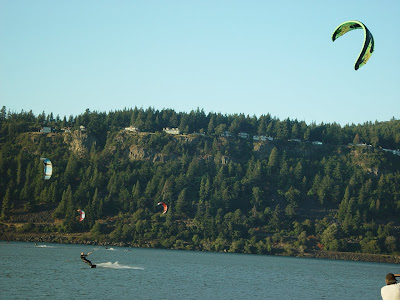
Bridges over the Columbia river, Mt. Hood and kite boarding on the Columbia river.
I always enjoy bridges with unique design. Along the Columbia river east of Portland, there are a couple of aerial lift bridges. These are bridges which have a section that lifts vertically so that ships can pass under.
We are still quite a ways away from Mt. Hood, but it is very prominent on the horizon.
Where the Hood river joins the Columbia river we saw about 30 kite boarders and several sail boarders enjoying the winds and the water. The kite boarders have a large parasail type kite that has long cable leads attached to a handle and a harness which they wear. They ski back and forth and can jump 15-20 feet out of the water at times. It was fun to watch them and we wondered how they kept from getting tangled up in each others kites.
Onions! John Day river, John Deere dozer, windmills galore.
We missed a turn and as a result saw a part of Oregon that we hadn't planned to, but it was a good mistake. We went northeast from Burns and went through Vale Oregon. There is a lot of farming done around Vale, corn, wheat, alfalfa, turnips (I think) and onions, lots of onions. I had never seen onions grown on this scale. There were hundreds of acres of onions. They grow pretty much on top of the ground. When they are ready to harvest, they go through the field with a tool on the tractor that cuts the onion loose from the root and they are left in the field for a few days for the tops to wilt, then they have another machine that they pull through the field that picks them up and puts them in a wagon.
After spending the night in John Day Oregon, we went west to Dayville and then followed the John Day river through a canyon for about 75 miles. There was very little activity along the river because the land is very rugged but beautiful. We really liked this area. At one point we say a small John Deere dozer parked on the shoulder of the road, Jane said we needed to go back and get a picture for Nathaniel, one of our grandchildren who really loves machinery.
Up the road another 75 miles or so, near Wasco, we came upon the largest windmill generator farm we have ever seen. At one vantage point they spread across the horizon for as far as you could see. There are probably 200-300 in this one area, but it is impossible to get them all in one picture. I read recently that these windmills cost about $3m each, so someone in Oregon has a huge investment in wind energy just in this one location.
Subscribe to:
Posts (Atom)